Müller Ice Cap Daily Report Monday May 22th
The first radar line
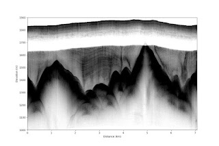
This morning we started the first radar line going in a box 5 km from camp. Unfortunately, the balloon deflated at the far edge of the box and we had to drag the PolyPod and then the deflated balloon with antennas back to camp. The data line, however, looks really great with traceable layers though the ice. The bedrock is really rough. In camp we started a firn core, but at a depth of 2 m the density reached that of ice… Targeting a high site location (15 m higher than the camp..) with traceable layers a site at 2.5 to 3 on the attached RES image might be a possible drill site. We will try a small line perpendicular to the presented RES line tomorrow.
What we have done:
1. Made the first 5 km RES line
2. Had a 2 hour rescue mission to get all equipment back to camp
3. Drilled a 2 m firn core before reaching solid ice.
4. Processed the RES data
5. Made chocolate chip cookies (Thanks Tamara and Niels)
Weather: In the morning blue sky with patches of ground fog. During the day overcast with snow and blowing snow, during evening clearing to blue sky. Wind from SW most of the day 12-16 kn dropping to 7 knots in the evening.
Figure captions:
The first RES image
The radar train in trouble
View from the PolyPod


